| INTRODUCTION | |||||||||||||||||||||||||||||||||||||||||||||||||||||||||||||||||||||||||||||||||||||||||||||||||||||||||||||||||||||||||||||||||||||||||||||||||||||
 With its rainforest, abundant wildlife, jungle streams, waterfalls, interesting plant life, secluded beaches, panoramic rocky shoreline, bizarre rock formations and extensive network of trekking trails, Bako National Park offers visitors an excellent introduction to the rainforest and coastline of Borneo. Bako may not have an instantly recognisable star attraction, but there can be very few places in the world that pack so much natural beauty into such a limited area, all just 37 km from Kuching. Its accessibility - and its sheer range of attractions and activities - have made Bako one of the most popular parks in Sarawak.
Gazetted in 1957, Bako is Sarawak’s oldest national park, covering an area of 2,727 hectares at the tip of the Muara Tebas peninsula. It is one of the smallest national parks in Sarawak, yet one of the most interesting, as it contains almost every type of vegetation found in Borneo. The well-maintained network of nature trails - from easy forest strolls to full-day jungle treks – allows visitors to get the most out of this unique environment.
| |||||||||||||||||||||||||||||||||||||||||||||||||||||||||||||||||||||||||||||||||||||||||||||||||||||||||||||||||||||||||||||||||||||||||||||||||||||
 | |||||||||||||||||||||||||||||||||||||||||||||||||||||||||||||||||||||||||||||||||||||||||||||||||||||||||||||||||||||||||||||||||||||||||||||||||||||
| THE RAINFOREST AND OTHER VEGETATION | |||||||||||||||||||||||||||||||||||||||||||||||||||||||||||||||||||||||||||||||||||||||||||||||||||||||||||||||||||||||||||||||||||||||||||||||||||||
 Bako contains an incredible variety of plant species and vegetation types, and this is one of the park’s great attractions. At Bako it is possible to see almost every type of vegetation found in Borneo. 25 distinct types of vegetation form seven complete eco-systems - Beach Vegetation, Cliff Vegetation, Kerangas or Heath Forest, Mangrove Forest, Mixed Dipterocarp Forest, Padang or Grasslands Vegetation and Peat Swamp Forest. It is easy to explore these eco-systems via the jungle trails. The contrasts are so distinct that you do not have to be a scientist to notice the differences. Furthermore, most of the different vegetation types are found close to the park HQ at Telok Assam. | |||||||||||||||||||||||||||||||||||||||||||||||||||||||||||||||||||||||||||||||||||||||||||||||||||||||||||||||||||||||||||||||||||||||||||||||||||||
| |||||||||||||||||||||||||||||||||||||||||||||||||||||||||||||||||||||||||||||||||||||||||||||||||||||||||||||||||||||||||||||||||||||||||||||||||||||
| WILDLIFE | |||||||||||||||||||||||||||||||||||||||||||||||||||||||||||||||||||||||||||||||||||||||||||||||||||||||||||||||||||||||||||||||||||||||||||||||||||||
 Bako is probably the best place in Sarawak for wildlife experiences. The park has been a protected area since 1957, so the animals are less wary of humans. Visitors, especially those who stay overnight, will have countless opportunities to observe and photograph various types of wildlife.
The best times for seeing wildlife at Bako are just after dawn and just before dusk, when the animals are at their most active. You are more likely to see animals on the trails if you go in small groups, walk slowly, keep as quiet as possible, and listen out for sounds and movements in the forest. For example, you are likely to hear a strange grunting sound or the crash of leaves long before you actually see a proboscis monkey.
Telok Assam, the area around the HQ, is a great place for seeing wildlife. Long-tailed macaques, silvered langurs or leaf-monkeys, common water monitors, plantain squirrels, wild boar and mouse deer are all found here. Watch out for the macaques as they are possibly the most fearless monkeys on earth. They will raid dustbins and kitchens in the resthouses, or scamper into the canteen to steal food or an unguarded bag. Keep all doors locked and never encourage them by offering food. In contrast to the unruly macaques, the silvered leaf-monkey or silvered langur is a docile and attractive creature. Adults have silver-grey fur and a spiky crest of head hair, whilst the infants are covered in bright orange fur.
 Bako is also home to approximately 275 rare proboscis monkeys, found only in Borneo. The male is an odd-looking creature, with a huge pendulous nose and a large pot-belly, weighing in excess of 20 kg. Both male and female are covered in reddish-brown fur with grey limbs and a white tail. They are mostly arboreal (tree-dwelling), moving about the forest or mangroves in small groups and feeding on young leaves, shoots, sour fruits and seeds. Although it requires some patience, an encounter with a group of proboscis is likely to be the highlight of your trip to Bako. The best times are early in the morning or in the hours before dusk. Telok Delima and Telok Paku are the best trails for viewing the proboscis. The mangroves at Telok Assam are also a good place for viewing proboscis monkeys.
Otters are delightful creatures to watch, and two species are found at Bako - the oriental small-clawed otter and the hairy-nosed otter. They spend most of their time in the water, feeding on fish, frogs and other small animals. Oriental small-clawed otters are occasionally seen at Sungai Assam, swimming in the river or running across the mud searching for food. Hairy-nosed otters are sometimes seen early in the morning around the mangroves at Telok Assam.
 The Bornean bearded pig, Bako’s largest mammal, is distinguished from other wild pigs by prominent bristles either side of its snout. Bearded pigs are often found around the park HQ scavenging for food or wallowing in mud.
The largest of Bako’s many lizard species is the common water monitor, olive green in colour and reaching a length of 2 metres. Young monitors are green with yellow spots and therefore easier to see. They are strong swimmers and can stay submerged for a considerable length of time. Monitors are scavengers, feeding on carrion and occasional live prey. They are often found near the accommodation area or near the boat jetty, scavenging for scraps of food. You may also see their tracks at the park’s beaches.
The small, brownish grey skink or sun lizard is often seen basking on rocks at the beach or scurrying away from the paths. The attractive green crested lizard, common throughout the park, is usually bright green but is capable of changing colour if alarmed. Flying lizards are occasionally seen launching themselves from tree trunks and gliding through the air.
 Bako is home to a number of snakes, most of which are harmless. They are well camouflaged, and usually slide off into the undergrowth at the first sign of danger. The grass green whip snake is easily recognised by its bright colour, pencil-thin body and long snout. The paradise tree snake’s black upper body is marked with green spots whilst its underside is yellowy-green with red spots. The only poisonous snake that is occasionally seen is the Wagler’s pit viper that, like all pit vipers, has a broad, flat, triangular head.
Bako is a fascinating place for bird watching, as over 150 species have been recorded here. Although many of these can be seen around the accommodation area, you need to hit the trails to appreciate the full variety of Bako’s bird life. The mangroves at Telok Assam are an excellent place to start. Serious bird watchers should take a good pair of binoculars and the Pocket Guide to the Birds of Borneo, which is widely available in Kuching.
Rock pools and mangroves are good places to search for small animals such as mudskippers and crabs, especially sky-blue fiddler crabs and shell-dwelling hermit crabs. Bako also has its fair share of insects. Watch out for them on the forest floor and hear them everywhere.
 Bako’s nocturnal creatures include the flying lemur, pangolin, mouse deer, various bats, tarsier, slow loris and palm civet. If you take a night walk through the forest near the Park HQ you may catch sight of some these creatures, as well as spiders that shine when a flashlight is played on them, glow worms and fireflies, You will certainly hear crickets, cicadas, frogs, and maybe owls. The beach by the park HQ is also a great place for a night walk. If the tide is out you may see crabs, prawns, anemones, starfish, annelid worms and young shrimp in the small pools. | |||||||||||||||||||||||||||||||||||||||||||||||||||||||||||||||||||||||||||||||||||||||||||||||||||||||||||||||||||||||||||||||||||||||||||||||||||||
| |||||||||||||||||||||||||||||||||||||||||||||||||||||||||||||||||||||||||||||||||||||||||||||||||||||||||||||||||||||||||||||||||||||||||||||||||||||
| TREKS AND TRAILS | |||||||||||||||||||||||||||||||||||||||||||||||||||||||||||||||||||||||||||||||||||||||||||||||||||||||||||||||||||||||||||||||||||||||||||||||||||||
 Bako’s extensive trail system is made up of 16 colour-coded jungle trails which offer a range of walking and hiking options. The fit and adventurous can opt for full-day jungle hikes or overnight camping expeditions, whilst those who prefer to take it easy can opt for a relaxing forest walk. The following table provides details of approximate trekking times and distances and the colour codes used in the park.
The following paragraphs provide brief details of each of trails. If you require further information, please consult the Park Rangers.
|
Selasa, 30 Julai 2013
About Bako National Park

Taman Negara
Taman Negara Malaysia
Daripada Wikipedia, ensiklopedia bebas.
| Taman Nasional Taman Negara | |
|---|---|
IUCN Kategori II (Taman Negara)
|
|
| Lokasi | Malaysia |
| Bandar terdekat | Kuala Tembeling |
| Kawasan | 4,343 km² |
| Ditubuhkan | 1938/1939 |
| Badan pentadbir | Jabatan Perlindungan Hidupan Liar dan Taman Negara |
Taman Negara terletak di antara sempadan 3 negeri iaitu Pahang, Terengganu, dan Kelantan, yang mana masing-masing memiliki kawasan milik sendiri. Enakmen Taman Negara (Pahang) No.2 pada 1939 dibuat untuk Pahang, Enakmen Taman Negara (Kelantan) No.14 pada 1938 untuk Kelantan, dan Enakmen Taman Negara (Terengganu) No.6 pada 1939 untuk Pahang. Semua enakmen memiliki persamaan kandungan.
Taman Negara Pahang merupakan yang terbesar dengan keluasan 2,477 km², diikuti oleh Taman Negara Kelantan seluas 1,043 km², dan Taman Negara Terengganu seluas 853 km².
Taman ini menjadi sebuah destinasi eko-pelancongan terkenal di Malaysia. Terdapat banyak daya tarikan dari segi geologikal dan biologikal di taman ini. Gunung Tahan merupakan titik tertinggi di Semenanjung Malaysia terletak di Taman Negara, pendaki boleh menggunakan Kuala Tahan atau Merapoh sebagai titik permulaan ekspedisi pendakian itu. Taman Negara mempunyai banyak haiwan mamalia yang jarang ditemui dan semakin pupus seperti harimau, tenuk, gajah, rusa, babi hutan, pelanduk, dan seladang. Sungai Tahan menjadi kawasan habitat kepada Ikan Kelah, sejenis ikan pertandingan.
Daya tarikan lain boleh ditemui di Kuala Tahan (tempat utama Taman Negara di Pahang) termasuk laluan kanopi, Gua Telinga, dan Lata Berkoh. Pengunjung dapat menikmati keindahan hutan hujan tropika, kicauan burung, ataupun merentas hutan (contoh: Tenor Rintis) dan pemandangan sungai ketika melalui Sungai Tahan.
Semua pengunjung mesti mendapatkan kebenaran/permit daripada Jabatan Perlindungan Hidupan Liar dan Taman Negara sebelum menjejakkan kaki ke Taman Negara. Terdapat banyak hostel dan hotel di taman ini.
Pelancong ke Taman Negara juga boleh memilih untuk menyertai aktiviti memancing terutamanya di Lata Berkoh dan Sungai Kenyam. Terdapat 300 spesies ikan terutamanya dari keluarga kap seperti ikan kelisa, ikan kelah, dan lain-lain lagi banyak terdapat di sungai-sungai di Taman Negara. Pelancong juga boleh menyewa bot untuk aktiviti memancing dan sukan air.
Isi kandungan
Pelancongan


Taman negara ini yang diisytiharkan secara rasminya oleh Sultan Kelantan, Pahang dan Terengganu (sewaktu sambutan Jubli Perak King George) diwartakan bagi memelihara alam semulajadi kawasan ini. Taman ini dinamakan Taman Negara setelah negara mencapai kemerdekaannya pada tahun 1957.
Aktiviti paling popular di Taman Negara ialah bersampan di sungai dan meneroka laluan trek hutan. Laluan Kanopi yang tedapat di sini juga sungguh menarik bagi memberikan pelawat pemandangan jarak dekat aktiviti haiwan dan tumbuhan di bahagian kanopi hutan yang tinggi.
Pondok pemerhatian juga disediakan bagi keselesaan pelawat untuk memerhati hidupan liar di sini. Pondok kecil yang dibina tinggi dari atas tanah membolehkan pelawat bermalam bagi memerhati hidupan liar di dalam habitat semulajadinya. Pelawat juga boleh meneroka gua sama ada menggunakan bot atau pun berjalan kaki.
Taman Negara adalah sebuah hutan hujan yang tertua di dunia yang dianggarkan berusia 130 juta tahun. Kekayaan dan kepelbagaian hidupan semulajadi di sini sangat menakjubkan dan menjadikannya salah satu eko-sistem yang paling rumit dan kaya di dunia.
Tips
Gunakan pakaian yang nipis dan longgar; kemeja-t lengan panjang yang selesa dan seluar panjang untuk perlindungan dari serangga dan luka cakaran. Pada masa-masa tertentu, keadaan di dalam hutan ini boleh menjadi sejuk. Bawa bersama jaket kalis air untuk keselesaan anda. Ketika meneroka hutan, pilih laluan trek yang boleh anda sempurnakan sebelum matahari terbenam dan pastikan anda memberitahu rancangan anda untuk meneroka kepada orang lain agar mereka boleh menjangka bila anda akan pulang dari penerokaan anda. Anda disarankan supaya tidak melencong dari laluan yang telah ditandakan di dalam hutan ini.Pengangkutan
Keretapi Pintu masuk ke Taman Negara iaitu Kuala Tembeling yang dihubungkan dengan Kuala Lumpur, Singapura dan Kota Bharu (melalui Tumpat) oleh laluan keretapi. Keretapi dari stesen-stesen tersebut berhenti di Tembeling Halt, kira-kira setengah jam perjalanan dari jeti Kuala Tembeling dengan menaiki kereta.Bot Pintu masuk utama untuk ke Taman Negara ialah menerusi Kuala Tembeling di mana pelawat boleh menaiki sampan yang bertolak pada pukul 9.00 pagi dan 3 petang setiap hari (kecuali hari Jumaat apabila bot bertolak pada pukul 2.30 petang), dalam perjalanan yang memakan masa selama 3 jam menuju ke Kuala Tahan. Mutiara Taman Negara Resort juga menyediakan perkhidmatan bot laju yang cuma mengambil masa selama 45 minit untuk sampai ke Kuala Tahan. Bot laju ini bertolak dari Kuala Tembeling pada pukul 10.30 pagi dan 1.30 petang setiap hari. Cara termudah untuk ke Taman Negara ialah sama ada melalui Jerantut di dalam perjalanan darat yang mengambil masa selama 3 jam dari Kuala Lumpur. Jika anda memandu kenderaan pacuan empat roda, anda boleh menggunakan jalan pembalakan hingga ke Kuala Tahan di mana anda perlu menaiki bot merentas Sungai Tahan untuk memasuki Taman Negara.
Bas atau Teksi Perkhidmatan teksi ke Jerantut boleh didapati dari Stesen Bas Puduraya di Kuala Lumpur. Anda juga boleh menaiki bas ke Jerantut yang boleh didapati di Stesen Bas Jalan Tun Razak di Kuala Lumpur. Dari Jerantut, anda boleh menaiki bas tempatan atau teksi untuk ke Kuala Tembeling.
Jumaat, 26 Julai 2013
Tentang Hutan DI Seluruh Dunia
HUTAN YANG TERBESAR DI DUNIA
Top 10 Negara dengan Hutan Terbesar
Hutan adalah kawasan atau wilayah yang ditumbuhi atau tertutup oleh pepohonan dan tumbuhan lainnya. Hutan adalah penyuplai utama oksigen dan paru-paru dunia. Hutan juga merupakan sumber keanekaragaman hayati dan sumber daya alam (kayu, energi, sumber daya mineral). Berikut ini adalah Top 10 negara dengan hutan terbesar dunia.
10. Negara : India
Luas area : 677,598 km2Persentase dari total wilayah negara : 21,17%
India merupakan negara dengan hutan terbesar kesepuluh dunia. Wilayah India pernah tertutup hutan lebat. Hutan India merupakan rumah dari spesies burung yang terancam punah dan satwa liar lainnya. Ancaman deforestasi juga mengintai hutan India, produk kayu bakar dan hutan sebagai sumber energi primer adalah penyebab utama berkurangnya wilayah hutan di India.
9. Negara : Peru
Luas area : 685,536 km2Persentase dari total wilayah negara : 53,34%
Peru adalah negara dengan hutan terbesar kesembilan dunia. Setengah dari wilayah negara Peru juga tertutup oleh hutan hujan Amazon. Karena wilayah Peru yang terletak di Amerika Selatan dan berbatasan dengan Brazil yang memiliki 60% wilayah Amazon.
8. Negara : Indonesia
Luas area : 847,522 km2Persentase dari total wilayah negara : 45,56%
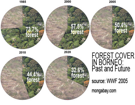
Indonesia negara kedelapan dengan hutan terbesar dunia. Indonesia merupakan rumah hutan hujan terluas di kawasan Asia. Hutan Indonesia merupakan rumah dari hampir 30 ribu spesies tumbuhan. Hutan Indonesia yang juga diandalkan sebagai paru-paru dunia akhir-akhir ini mengalami deforestasi yang sangat menyedihkan. Hutan Indonesia khususnya di Kalimantan pada tahun 2010 hanya tinggal 44.4% dan diperkirakan tahun 2020 semakin berkurang dan tinggal 32.6%.
7. Negara : Republik Demokratik Congo
Luas area : 1,329,707 km2Persentase dari total wilayah negara : 56,71%
Republik Demokratik Congo memiliki hutan terbesar ketujuh dunia. Namun sayang konflik kerap terjadi di negara ini. Perang bersaudara yang berkepanjangan sangat mengganggu pertumbuhan perekonomian Congo, yang berdampak pada deforestasi hutan Kongo demi kepentingan perut semata. Penebangan komersial, pembukaan lahan untuk pertanian subsisten, dan perselisihan antar warga telah menghancurkan luas hutan, penduduk hutan terlantar, dan mengakibatkan perluasan perdagangan hewan liar.
6. Negara : Australia
Luas area : 1,632,912 km2Persentase dari total wilayah negara : 21,23%
Sebagai negara terluas keenam dunia, Australia juga memiliki hutan terbesar keenam dunia. Australia memiliki banyak hutan yang penting mulai dari hutan tropis hingga mangrove, semua memiliki peran yang penting bagi Australia pada khususnya dan dunia pada umumnya.
5. Negara : China
Luas area : 2,054,056 km2Persentase dari total wilayah negara : 21,40%
Cina merupakan negara terluas keempat dunia dan memiliki hutan terbesar kelima dunia. Cina memiliki hutan hujan tropis yang luas di selatan Yunnan, namun sangat disayangkan keberadaan hutan tersebut menurun sebanyak 67% dalam 30 tahun terakhir.
4. Negara : Amerika Serikat
Luas area : 3,034,070 km2Persentase dari total wilayah negara : 31,51%
Amerika sebagai negara terluas ketiga di dunia, Amerika memiliki hutan terbesar keempat di dunia. Amerika termasuk negara yang concern dalam menjaga hutannya. Sebuah lembaga nirlaba konservasi dibentuk untuk melindungi dan memulihkan hutan di Amerika.
3. Negara : Kanada
Luas area : 3,101,340 km2Persentase dari total wilayah negara : 31,06%
Sebagai negara terluas di dunia kedua, Kanada merupakan negara dengan hutan terbesar ketiga di dunia. Kanada memiliki hutan boreal (taiga) yang sangat luas yang merupakan aspek yang sangat penting bagi negara Kanada yaitu merupakan ikon dalam sejarah Kanada, perekonomian Kanada termasuk seni dan kehidupan sosial.
2. Negara : Brazil
Luas area : 4,714,920 km2Persentase dari total wilayah negara : 55,37%
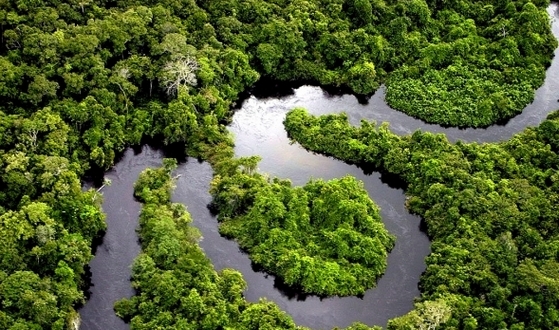
Brazil memiliki hutan terbesar kedua di dunia, kita mengenal hutan hujan Amazon. Amazon menutupi hampir 9 negara termasuk Brazil dengan peresentase 60%.
1. Negara : Russia
Luas area : 8,085,986 km2Persentase dari total wilayah negara : 47,35%
Sebagai negara terluas dunia, Rusia juga merupakan negara dengan hutan terbesar di dunia dengan luas lebih dari 8 juta km2 atau 22% dari hutan di dunia. Hutan di Rusia banyak terdapat hutan tua yang merupakan warisan alam dan menjadi wadah utama dari keanekaragaman hayati.

Tentang Hutan Hujan Tropika
Hutan Hujan Tropika
Hutan Hujan Tropika adalah hutan yang paling luas
dan terpenting di Malaysia. Hutan ini meliputi kira-kira 70% daripada
jumlah kawasan hutan di Malaysia. Kira-kira 46% daripada keluasan hutan
ini terdapat di negeri Sarawak, 31 % di Semenanjung Malaysia dan 23% di
negeri Sabah.
 |
| Hutan-hutan Di Malaysia |
Hutan ini
tumbuh di kawasan kurang daripada 1200 meter. Hutan ini terdapat di kaki
bukit atau cerun gunung di bahagian tengah Semenanjung Malaysia dan
bahagian pendalaman Sabah dan Sarawak. Hutan ini juga dikenali sebagai Hutan Dipterokarp Tanah Pamah.
 |
| Epifit: Paku Tanduk Rusa |
 |
| Ciri-cir: Berakar banir |
Ciri-ciri Hutan Hujan Tropika:
- Malar Hijau - pokok-pokok tidak menggugurkan semua daun pada masa yang sama;
- tumbuhan rapat-rapat dan tebal;
- menjadi habitat bagi hampir dua pertiga daripada jumlah spesies tumbuh-tumbuhan di bumi;
- bercampur aduk - terdapat pelbagai spesies pokok yang tumbuh dalam satu kawasan;
- berakar banir, tumbuh berlapis-lapis dan mempunyai batang yang lurus dan tinggi;
- terdapat pelbagai jenis kayu keras yang bernilai dan bermutu tinggi seperti meranti, cengal, keruing, merbau, balau, seraya dan kapur;
- terdapat empat lapisan yang nyata iaitu lapisan emergen, kanopi, tengah dan bawah.
 |
| Lapisan Pokok Dalam Hutan Hujan Tropika |
Terdapat pelbagai jenis hidupan liar yang hidup didalam Hutan Hujan Tropika mengikut lapisan ketinggian hutan tersebut:
 |
| Hidupan Liar Mengikut Lapisan Ketinggian Di Dalam Hutan Hujan Tropika |
SABAH NATIONAL PARK (KINABALU)
Kinabalu National Park
|
Kinabalu National Park, about 90 kilometres from Kota Kinabalu, is one of the world's most significant natural environments. The park is home to thousands of types of flora and fauna that are native to the area, and several hundred that are found only in the park. |
|
|
As such, Kinabalu National Park was declared a UNESCO World
Heritage site in 2000, the first in Malaysia. While its tourist trails
are well-worn, the majority of the park is an unspoilt paradise for rare
flora and fauna. For those who aren't keen on testing themselves on Mt Kinabalu's slopes, there is still much to enjoy from a visit to the park. The presence of Mt Kinabalu, the highest mountain in South-East Asia, is one of the contributing factors to the wide variety of animal, bird, insect and plant life found in the park. |
 The stunning blooms of orchids from Kinabalu National Park. |
|
The terrain ranges from lush, green rainforest at the park's
lowest altitudes, while further up the mountain, rhodendron and
coniferous forest is prevalent. At the highest altitudes, stunted plant
growth and small marsupials survive in a harsh environment. Orchids and carnivorous pitcher plants are among the park's most famous plants, although they are rare along the park's most worn tourist trails. However, they are all on display in a botanical walk near park headquarters, where visitors can view some of the area's most beautiful flora. The most famous of the pitcher plants endemic to Kinabalu National Park is Nepenthes raja, a giant pitcher plant whose bell can hold more than three litres of water. There are a number of other species of pitcher plants in the park, and these can be seen just off some of the tracks in the park. |
 One of the many varieties of pitcher plant in the park. |
|
Kinabalu National Park is also home to the world's largest
flower, the Rafflesia, which blooms exceptionally rarely and then only
for a matter of days. Unlike most of its floral brethren, the Rafflesia emits a foul smell, reminiscent of rotting meat. The stench attracts flies and insects, which the plant then feasts upon. With a diameter of up to one metres and a potential weight of 10 kilograms, the blooming of the Rafflesia is an event keenly awaited by botanists around the world. | |
Gunung Mulu National Park
Gunung Mulu National Park
From Wikipedia, the free encyclopedia
Coordinates: 4.132°N 114.919°E
| Gunung Mulu National Park | |
| Protected Area | |

Mount Mulu viewed from a distance
|
|
| Country | Malaysia |
|---|---|
| State | Sarawak |
| Highest point | |
| - location | Mount Mulu |
| Area | 528.64 km2 (204 sq mi) |
| Geology | Extensive caves including the world's largest cave chamber |
| Plant | Nepenthes pitcher plants, Strangler figs |
| Animal | Gibbons, Orangutans, Rhinoceros Hornbill, Sumatran Rhinoceros, Sun Bear |
| Founded | 1974 |
| Management | Sarawak Forestry |
| UNESCO World Heritage Site | |
| Name | Gunung Mulu National Park |
| Year | 2000 (#24) |
| Number | 1013 |
| Region | Asia-Pacific |
| Criteria | vii, viii, ix, x |
The national park is named after Mount Mulu, the second highest mountain in Sarawak.
Geology and landforms
Gunung Mulu National Park is famous for its limestone karst formations. Features include enormous caves, vast cave networks, rock pinnacles, cliffs and gorges. Mount Mulu is a sandstone mountain rising to 2,376 m (7,795 ft).Gunung Mulu National Park has the largest known natural chamber or room - Sarawak Chamber, found in Gua Nasib Bagus. It is 2,300 feet (700 m) long, 1,300 feet (396 m) wide and at least 230 feet (70 m) high. It has been said that the chamber is so big that it could accommodate about 40 Boeing 747s, without overlapping their wings. The nearby Deer Cave was, for many years, considered the largest single cave passage in the world.


Mulu's limestones belong to the Melinau Formation and their age is between 17 and 40 million years (Late Eocene to Early Miocene).
Stratigraphically below the limestones, and forming the highest peaks in the south east sector of the Park including Gunung Mulu, lies the Mulu Formation (shales and sandstones). The age of these rocks is between 40 and 90 million years (Late Cretaceous to Late Eocene).
Fauna
Eight species of hornbill have been spotted in Mulu including the Rhinoceros Hornbill Buceros rhinoceros which features on Sarawak state emblem, the White-crowned Hornbill Berenicornis/Aceros comatus and the Helmeted Hornbill Buceros vigil with its large solid casque (bill).Twenty seven species of bat have been recorded in Mulu. Deer Cave in the southern limestone hills of the park is home to an enormous colony of Wrinkle-lipped bats (Tadarida plicata). The bats exit the cave almost every evening in search of food in a spectacular exodus. A huge mound of guano in the cave is evidence of the size of the bat colony that roosts in the cave's high ceilings.
Mulu's mammals also include the Bearded pig Sus barbatus, the moonrat Echinosorex gymnurus, shrews, the Bornean Tarsier Tarsius bancanus, the long-tailed Macaque Macaca fascicularis, gibbons, squirrels, and three types of deer including the small barking deer and mouse deer. The small Malaysian sun bear Helarctos malayanus, which is the only bear known in South-East Asia, has also been identified in Gunung Mulu National Park.
Flora

Access
Mulu National Park is a very remote access area; the only practical way of getting to and from it is by air, through Mulu Airport. There are flights between Mulu Airport and Miri (daily), Kuching (Tuesdays, Thursdays and Saturdays) and Kota Kinabalu (Tuesdays, Thursdays and Saturdays) on MASwings.[1] Alternatively, it is possible to travel by river from Miri, which is about 100 km away, using a riverboat, then a chartered long boat, which in total takes around 12 hours. Before the opening of the airport and the opening of a helipad in 1991, this was the only way to reach the national park.Excursions to Mulu continues to retain the sense of adventure associated with its original exploration through the provision of adventure caving and other adventure activities. The primary focus, however, has shifted to the promotion of an awareness of the significance of the park and its environment through the provision of ecotourism activities that foster understanding and appreciation of the parks values. Accommodation is available onsite at Gunung Mulu National Park headquarters, as well as at the Royal Mulu Resort and across the Melinau River at Benarat Inn also known as Benarat Lodge. Homestays offered by locals, and other typically cheaper lodging are available across the river.
See also
References
- Hans P. Hazebroek and Abang Kashim bin Abang Morshidi National Parks of Sarawak, 2000, Perpustakaan Negara Malaysia, ISBN 983-812-032-4
- David W Gill. "The Gunung Mulu National Park Nomination for World Natural Heritage Listing. Sarawak, Malaysia". 1999. Sarawak Forest Department.
External links
 |
Wikimedia Commons has media related to: Gunung Mulu National Park |
- Mulu National Park official website
- UNESCO site datasheet
- Mulu Caves Project
- Database & Bibliography of the Caves of East Malaysia
- Gunung Mulu National Park information from Tour Malaysia
- Caves of Mulu 2007 Expedition
Gunung Mulu National Park travel guide from Wikivoyage
- Travel information from Virtual Malaysia
- Daily Mail article on caves in the Park
Antara Jenis-jenis Hutan yang Terdapat Di Malaysia
ANTARA JENIS-JENIS HUTAN DI MALAYSIA.
Malaysia antara negara yang mempunyai HUTAN HUJAN TROPIKA. Kebanyakkan hutan hujan tropika di Malaysia telah berusia beratus tahun malah ada yang berusia beribu tahun. Hal ini telah menjadi tarikan pelancong dari dalam mahupun luar negara, keindahan hutan hujan tropika di Malaysia telah memukau para pelancong yang telah pergi ke hutan tersebut.
Sarawak dan Sabah antara negeri yang mempunyai Hutan Hujan Tropika yang paling besar dan banyak yang menjadi kegilaan para pelancong untuk pergi berkunjung ke hutan tersebut. Kebanyakkan hutan yang terdapat di Malaysia telah diperlihara oleh Kementerian Alam Sekitar dan hutan tersebut dikenali sebagai Taman Negara dan Hutan Simpan. Selain hutan hujan tropika, Malaysia juga mempunyai Hutan Paya, Hutan kawasan tinggi.
ANTARA HUTAN YANG TERDAPAT DI MALAYSIA
CONTOH NAMA HUTAN YANG DIKENALI SEBAGAI TAMAN NEGARA
Semenanjung Malaysia
GAMBAR HUTAN HUJAN TROPIKA:


GAMBAR HUTAN PAYA:


Malaysia antara negara yang mempunyai HUTAN HUJAN TROPIKA. Kebanyakkan hutan hujan tropika di Malaysia telah berusia beratus tahun malah ada yang berusia beribu tahun. Hal ini telah menjadi tarikan pelancong dari dalam mahupun luar negara, keindahan hutan hujan tropika di Malaysia telah memukau para pelancong yang telah pergi ke hutan tersebut.
Sarawak dan Sabah antara negeri yang mempunyai Hutan Hujan Tropika yang paling besar dan banyak yang menjadi kegilaan para pelancong untuk pergi berkunjung ke hutan tersebut. Kebanyakkan hutan yang terdapat di Malaysia telah diperlihara oleh Kementerian Alam Sekitar dan hutan tersebut dikenali sebagai Taman Negara dan Hutan Simpan. Selain hutan hujan tropika, Malaysia juga mempunyai Hutan Paya, Hutan kawasan tinggi.
ANTARA HUTAN YANG TERDAPAT DI MALAYSIA
- HUTAN PAYA
- HUTAN KAWASANTINGGI
- HUTAN HUJAN TROPIKA.
CONTOH NAMA HUTAN YANG DIKENALI SEBAGAI TAMAN NEGARA
Semenanjung Malaysia
- Taman Negara
- Taman Negara Endau-Rompin
- Taman Negara Gunung Stong
- Taman Negara Royal Belum
- Pusat Perlindungan Hidupan Liar Krau
Johor
- Taman Negara Endau-Rompin
- Gunung Ledang
- Taman Negara Tanjung Piai
- Taman Negara Pulau Kukup
- Taman Negara Mersing
Pulau Pinang
Perlis
- Taman Negara Perlis
- Hutan Simpan Wang Pinang
Selangor
- Taman Warisan Selangor
- Pusat Perlindungan Hidupan Liar Sungai Dusun
- Taman Templer
Sarawak
- Taman Negara Bako
- Taman Negara Mulu
- Taman Negara Niah
- Taman Negara Bukit Lambir
- Taman Negara Similajau
- Taman Negara Gunung Gading
- Taman Negara Kubah
- Taman Negara Batang Ai
- Taman Negara Loagan Bunut
- Taman Negara Tanjung Datu
- Taman Negara Talang Satang
- Taman Negara Bukit Tiban
- Taman Negara Maludam
- Taman Negara Poko Bakau Rajang
- Taman Negara Gunung Buda
- Taman Negara Pulong Tau
- Taman Negara Kuching Wetlands
- Taman Negara Santubong
- Taman Negara Banjaran Bungo
- Taman Negara Terumbu Karang Miri-Sibuti
- Taman Negara Pulau Sampadi
- Taman Negara Pulau Seduku
- Taman Negara Ulu Menyang
- Taman Negara Ulu Sebuyau
- Taman Negara Sedilu
- Taman Negara Usun Apau
- Taman Negara Pergunungan Hose
- Taman Negara Banjaran Dulit
- Taman Negara Telang Usan
- Taman Negara Gunung Lumpur
- Taman Negara Batang Lassa
- Taman Negara Paya Bakau Krian
- Taman Negara Bruit-Patok
- Taman Negara Pelagus
- Taman Hidupan Liar Lanjak-Entimau
- Taman Hidupan Liar Sibuti
- Taman Hidupan Liar Pulau Tukong Ara-Banum
- Pusat Perlindungan Hidupan Liar Samunsam
- Pusat Perlindungan Hidupan Liar Matang
- Taman Semulajadi Bau Limestone
- Rezab Semulajadi Sama Jaya
- Rezab Semulajadi Gua Angin
- Rezah Semulajadi Stutong
- Rezab Semulajadi Semenggoh
- Rezab Semulajadi Bukit Hitam
- Rezab Semulajadi Bukit Sembiling
- Rezab Semulajadi Bukit Lima
Sabah
- Taman Kinabalu
- Taman Negara Tunku Abdul Rahman
- Taman Negara Kepulauan Penyu
- Taman Negara Pulau Tiga
- Taman Negara Bukit Tawau
GAMBAR HUTAN HUJAN TROPIKA:
GAMBAR HUTAN PAYA:
Langgan:
Catatan (Atom)